
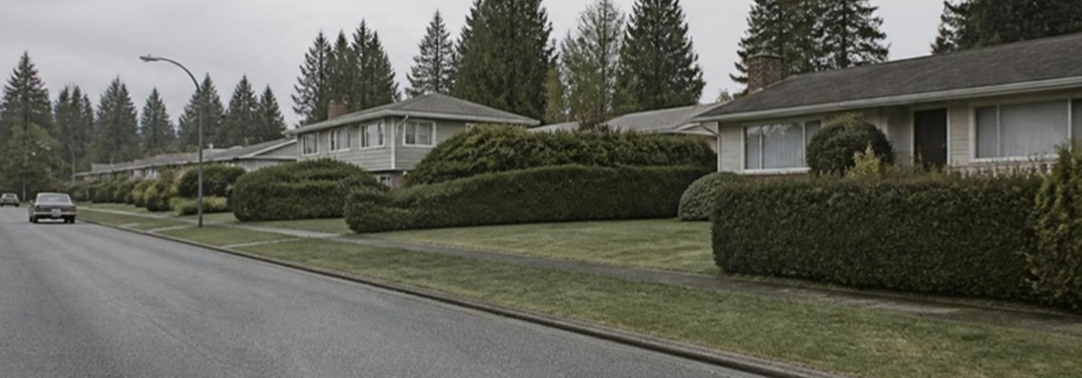
Blueridge looks like an ordinary post-war subdivision: quiet streets, big trees, houses on generous lots, a school and a park in the middle. Most of what actually decides whether a particular house here is a good buy has nothing to do with any of that.
Blueridge sits against the forest on the lower slopes of Mount Seymour, in the District of North Vancouver. That forest edge is the thing the District regulates hardest. Wildfire, slope, creek and streamside permit rules land on lots here that look identical to their neighbours from the street, and they can change what you are allowed to build.
This guide covers what is here, what the District’s own documents say about the land, how long the bus actually takes, and the things people who live here complain about. There are no price figures on this page. For current numbers, see this month’s North Shore market stats.
The short version
- It is the District of North Vancouver, not the City. Different council, different bylaws, different phone number.
- Built from the mid-1950s. Houses were being advertised here in September 1955, and the neighbourhood filled in over the following two decades.
- The land rules matter more here than in most neighbourhoods. Wildfire, slope, creek and streamside development permit areas all apply somewhere in and around Blueridge. Check the specific address on the District’s GEOweb map before you make an offer.
- That can also cap what you build. The District’s own material says lots in natural-hazard permit areas were put forward to be exempted from the provincial four-unit small-scale housing rules.
- One bus goes through the middle of it. The 214 runs down Berkley and Carnation to Phibbs Exchange in about 12 minutes, and three weekday morning trips carry on to Burrard Station in 46 to 47 minutes.
- Shops are not in Blueridge. Everything day-to-day is at Parkgate Village on Mount Seymour Parkway: grocery, pharmacy, liquor, library, community centre, doctors and dentists.
- It suits people who want the forest and quiet streets and will accept a car-dependent, shop-free neighbourhood with a single main road out.
On this page
- Where Blueridge is, and which city hall you deal with
- How Blueridge got here
- The streets, and how the neighbourhood divides
- What kind of money Blueridge is
- What makes one Blueridge street worth more than the next
- The houses, and what tends to need work
- The land rules that bite here: wildfire, slope, creek, trees
- The Berkley escarpment, and why the District has a landslide file on it
- What to check before you buy in Blueridge
- Daily life: Parkgate Village
- Parks, trails and recreation
- Schools
- Getting around, with real bus times
- What is being built and planned
- What locals like, and what they complain about
- Community life
- Who Blueridge suits, and who it does not
Where Blueridge is, and which city hall you deal with
Blueridge is on the east side of the Seymour River, north of Mount Seymour Parkway, climbing the lower slopes of Mount Seymour. It is one of the named neighbourhoods the District of North Vancouver uses on its own maps, alongside Seymour Heights, Windsor Park, McCartney Woods, Riverside East and Northlands.
This matters more than people expect. There are three separate local governments on the North Shore: the City of North Vancouver, the District of North Vancouver, and the District of West Vancouver. Blueridge is in the District. If you phone the City about a Blueridge permit, you have phoned the wrong government.
District of North Vancouver municipal hall is at 355 West Queens Road, North Vancouver, BC V7N 4N5. The main number is 604-990-2311. Building and permit enquiries go to 604-990-2480 or building@dnv.org. Tree and environment enquiries go to environment@dnv.org.
Everything municipal on this page can change. Bylaws get amended, permit areas get remapped, applications get approved or refused. Before you rely on any of it for a specific property, phone the District on 604-990-2311 or use the District’s contact page.
How Blueridge got here
Blueridge was forest until the middle of the 1950s. The Blueridge Community Association’s history page reproduces a newspaper advertisement for homes here dated Sunday 2 September 1955, and a photograph from the North Vancouver Archives taken the same month, catalogued as “Unidentified people associated with construction of housing development”.
The timing fits the rest of the Seymour side. Mount Seymour Provincial Park was established in 1936. The Museum of North Vancouver records that the replacement Second Narrows crossing, later renamed the Ironworkers Memorial Bridge, opened to traffic on 25 August 1960. Blueridge filled in over the two decades on either side of that date.
The valley behind the neighbourhood stayed closed. Metro Vancouver’s own management plan says the Lower Seymour Conservation Reserve opened to the public in 1987, after decades shut to protect the drinking water supply. The trail network Blueridge residents now use on their doorstep is younger than most of the houses.
The streets, and how the neighbourhood divides
Berkley Road and Berkley Avenue are the spine. Almost everything else hangs off them: Hyannis Drive, Sechelt Drive, Byron Road, Bronte Drive, Carnation Street, Swinburne Avenue, Layton Drive, Whitman Avenue, Hill Drive, Hardy Drive, Derbyshire Way, Arroyo Court, Wyat Place and Walpole Crescent.
A note on names. “Berkley” is a street, not a District neighbourhood. The District’s own neighbourhood map labels Blueridge, Seymour Heights, Windsor Park, McCartney Woods and Riverside East, and shows Berkley only as road names. Listings sometimes use “Berkley” as though it were an area. Ask which street the property is actually on.
The division that matters is not east and west but interior and edge. The Blueridge Community Association puts it plainly on its page about the provincial housing rules: lots in the interior of Blueridge are expected to allow up to four units, while lots along the borders are likely to be ineligible because of fire and other risks. The edge lots are the ones against the forest and the creeks. They are often the nicest to live on and the most constrained to build on.
One physical quirk worth knowing before you walk it: the association’s own neighbourhood map marks 48 walking-path shortcuts between streets, plus six Little Free Libraries and a community sharing garden. Blueridge is far more walkable on foot than it looks on a road map, because the road map does not show the cut-throughs.
What kind of money Blueridge is
Blueridge is a detached-house neighbourhood in one of the more expensive parts of Metro Vancouver, and it prices like one. It is generally less expensive than Deep Cove waterfront or the best of Edgemont, and more expensive than comparable housing off the North Shore entirely. There is very little here that is not a house, so the entry point is a house price.
Putting a figure on that in an article is a bad idea, because it would be wrong within a month. Current benchmark prices for North Vancouver detached, townhouse and apartment, updated monthly from Greater Vancouver REALTORS’ own data, are on the North Shore market stats page. If you want the numbers for one specific street, ask me and I will pull them.
What makes one Blueridge street worth more than the next
- Where the lot sits on the slope. Blueridge runs roughly two kilometres up from the Parkway. Higher usually means more outlook and more driveway to clear in a cold snap.
- Whether the lot is in a hazard permit area. A wildfire, slope or creek designation changes what you can build and adds a permit step. See the next section.
- How close it is to a trailhead. Backing onto the forest is the reason many people buy here. Living beside the parking that the forest generates is the reason some of them complain.
- Walk to Blueridge Park and the elementary school. The park and the school sit in the middle of the neighbourhood, and the footpath network feeds into them.
- Which road you use to get out. Berkley is the main way in and out for much of Blueridge, and it carries the traffic to prove it.
- Whether the house has been done. Most of the stock is old enough that the difference between an updated house and an original one is large.
The houses, and what tends to need work
There is no published census breakdown for Blueridge on its own, because Blueridge is a District map label rather than a Statistics Canada geography. Anyone quoting you “Blueridge demographics” is quoting an approximation.
What is published is district-wide. The District’s 2024 Housing Needs Report, working from 2021 census data, counts 32,700 homes in the District, of which 16,115 — about 49% — are single-detached houses. On age: 22% of the District’s housing was built in 1960 or earlier and 36% between 1961 and 1980. That is 58% of the housing stock built before 1981.
Blueridge sits squarely inside that older band. Houses advertised here from 1955 onward, on a neighbourhood that filled in through the 1960s and 1970s, means most of what you look at will be 50 to 70 years old unless it has been rebuilt.
For houses of that age anywhere on the North Shore, the recurring items are drainage and perimeter water management on a slope, original or part-replaced plumbing and wiring, roofs and skylights, older heating systems, and any addition or suite that may or may not have been permitted. None of that is specific to Blueridge, and none of it is a reason not to buy. It is a reason to get a proper inspection and to check the permit history. I have written both up separately: what actually breaks in an older North Shore house and how to check a building’s permit history.
On a sloped lot, one extra item: excavation. The District’s own excavation bulletin requires ink-sealed shoring designs from a geotechnical engineer for any excavation with a vertical cut of more than four feet, or benched steeper than forty-five degrees over four feet. If your renovation plan involves digging down, budget for the engineer.
The land rules that bite here: wildfire, slope, creek, trees
This is the part of a Blueridge purchase that almost nobody explains, and it is the part most likely to change what you can do with the property.
The District’s Official Community Plan, Bylaw 7900, adopted on 27 June 2011 and consolidated to 5 June 2026, designates development permit areas across the District. Five of them are relevant on the forest edge: Protection of the Natural Environment, Streamside Protection, Wildfire Hazard, Creek Hazard and Slope Hazard. Blueridge has no local area plan of its own. The old Seymour Local Plan of 2003 was rescinded when the district-wide plan came in, and the District now keeps it for reference only.
Wildfire hazard
The District’s wildfire development permit area FAQ says the area covers “all properties located in the District’s forested wildland / urban interface and some District Park areas”. If your property is in it and you plan to build a new or replacement house, a development permit is required.
The rules are physical, not just paperwork. Within 1.5 metres of the house there must be a fuel-free area with no flammable materials or landscaping, and between 1.5 and 10 metres only low-flammable planting. The District says its FireSmart guidelines are strongly recommended for auxiliary structures, new roofs and renovations inside the permit area too. The District also offers free FireSmart home assessments through its wildfire home hazard assessment programme.
Slope, creek and streamside
The same schedule of the community plan maps slope hazard, creek hazard and streamside protection areas. Blueridge Creek and McCartney Creek run through and beside the neighbourhood. Whether a given lot is caught is a question about that lot, not about the street.
How to check an actual address
The District tells you exactly where to look. From the wildfire FAQ: these areas “are identified on Geoweb on the District’s GIS website at http://geoweb.dnv.org/ under applications, properties, layers, layer manager, DPA Wildfire Hazard.” The other hazard layers sit in the same layer manager. Do this before you write an offer, not after.
The knock-on nobody mentions: four units, or not
British Columbia’s small-scale multi-unit housing legislation generally allows up to four units on a single-family lot, and up to six close to frequent transit. The District’s own fact sheet on the legislation records that land parcels already subject to one or more of the three natural-hazard development permit areas were put forward to be exempted from those requirements. Unserviced lots are exempt as well.
Read that alongside the community association’s expectation that Blueridge’s border lots are likely to be ineligible, and the practical conclusion is this: do not pay a premium for a Blueridge lot on the assumption you can put four units on it until you have confirmed that lot’s hazard status with the District. Under the province’s rules, six units depend on being within 400 m of a prescribed frequent bus stop, and the District’s two transit-oriented areas, at Phibbs Exchange and Capilano University, are about building heights near those hubs; neither is in Blueridge. On 13 April 2026 District Council also voted not to support implementing these small-scale housing rules, so confirm what applies to a lot before you rely on any of it.
Trees
Blueridge is a treed neighbourhood and the District’s Tree Protection Bylaw 7671 applies. A permit is needed for a large-diameter tree, which the District defines as 75 cm, 30 inches or 2.5 feet in diameter measured 1.3 metres above the ground.
Several of the “protected tree” categories catch Blueridge lots specifically:
- any tree on a slope greater than 36%;
- any tree within 15 metres of the top of bank of a watercourse;
- 30 metres of top of bank for lots greater than 0.5 hectares next to the Seymour River, among other named waterways;
- any tree within specified development permit areas;
- named species including arbutus, Garry oak, Oregon ash, Pacific yew, western white pine and yellow cedar.
Replanting is required: one replacement tree per tree removed on lots under 420 square metres, three per tree removed on larger lots. Enquiries go to environment@dnv.org or 604-990-2480. If your plan for a Blueridge house depends on taking down the big cedar at the back, ask first.
The Berkley escarpment, and why the District has a landslide file on it
Along the western edge, above Riverside Drive, the ground drops away sharply. The District has studied this slope in detail and publishes the reports.
BGC Engineering’s Phase 1 risk assessment, dated 13 January 2006, covers the escarpment between the corner of Berkley Avenue and Whitman Avenue at the north and the corner of Bendale Road and Berton Place at the south. It records that since 1972 heavy rainfall has triggered at least six extremely rapid landslides in that area, which it puts at about one landslide every 5.5 years.
The cause it identifies is not the natural slope alone. In the report’s words, “fill was indiscriminately placed at the top of the escarpment, locally oversteepening the top-of-slope and increasing the potential for landslides.”
The District followed the assessment with mitigation work and a district-wide landslide risk summary in 2010, which sets out how it classifies risk as broadly acceptable, tolerable or unacceptable, and recommends that properties along escarpment crests have access to the storm water system.
None of this makes the escarpment edge a bad place to live, and the work was done a long time ago. It does mean that if you are buying near the crest or the toe of that slope, you should read the District’s reports, check the slope hazard layer on GEOweb for the address, and ask a geotechnical engineer rather than an estate agent. Where surface water goes on a sloped lot is worth understanding before you buy, not after the first big November rain.
What to check before you buy in Blueridge
| What to check | Why it matters here | Where to check it |
|---|---|---|
| Hazard development permit areas on the lot | Wildfire, slope and creek designations change what you may build and add a permit step | GEOweb layer manager, geoweb.dnv.org; District 604-990-2480 |
| Small-scale multi-unit eligibility | Hazard-area lots were put forward for exemption from the four-unit rules | District planning, 604-990-2480 |
| Protected trees | Slopes over 36%, watercourse setbacks and listed species all trigger a permit | environment@dnv.org, 604-990-2480 |
| Slope and drainage | Documented landslide history on the Berkley–Riverside escarpment; fill at the top of slope was the identified cause | District public safety reports on geoweb.dnv.org; a geotechnical engineer |
| Permit history of the house | Most of the stock is 50 to 70 years old with decades of alterations | District records; see the permit history guide linked above |
| School catchment for the address | Catchments are set by address and are reviewed; family-of-schools groupings are not catchments | SD44 School Locator; SD44 604 903 3444 |
| Which bus, and at what time | The one-seat ride downtown runs weekday mornings only | Current TransLink timetables, translink.ca |
| Trailhead parking pressure on the street | Documented pinch point around Hyannis Drive and Berkley Avenue | Visit on a fine weekend morning |
Daily life: Parkgate Village
Blueridge has no shops. It has a park, a school and houses. Everything day-to-day happens at Parkgate Village, at 3650 Mount Seymour Parkway, a few minutes from anywhere in the neighbourhood.
The centre is anchored by a Safeway supermarket, and the centre’s own directory currently lists a Shoppers Drug Mart pharmacy, a Parkgate Farm Market, a butcher, a COBS Bread bakery, a bulk foods shop and a handful of cafés and takeaways. Spirits of Mt. Seymour, the private liquor store at 1133 Mt. Seymour Road, publishes its hours as 9am to 11pm, seven days a week.
One honest limitation: there is no chartered bank branch. The directory lists a credit union branch and a cash machine only. If you bank somewhere that needs a counter, that counter is in Lynn Valley or on Lonsdale.
Services are clustered on the same block. Parkgate Community Centre is at 3625 Banff Court, open 6am to 10pm Monday to Thursday, 6am to 9pm on Friday, 8am to 6pm on Saturday and 8am to 5pm on Sunday. Its gym holds eight badminton and pickleball courts, two full basketball courts, three volleyball courts and a climbing wall, and there is a pottery studio and a fitness centre. There is no pool and no ice rink at Parkgate.
Next door at 3675 Banff Court, Parkgate Library opened in 1994 and is open seven days a week: 10am to 8pm Tuesday to Thursday and 10am to 6pm on the other four days. It has a fireplace reading area, a quiet study room, public computers and children’s and teen sections. Vancouver Coastal Health also runs the Parkgate Community Health Centre on the second floor at 3625 Banff Court, on 604-904-6450.
Store hours and tenants change. Phone ahead rather than trusting this page.
Parks, trails and recreation
Blueridge Park is the neighbourhood park, on the 2400 block of Berkley Avenue. The District’s park inventory puts it at 1.70 hectares with a baseball diamond, a junior soccer field, a playground and open grass. The District replaced the playground for ages 5 to 12 and reopened it in spring 2023. NVRC books the grass field.
Other parks in and beside the area include Byron Park, Trillium Park, Windsor Park, and the larger McCartney Creek Park at 18.34 hectares and Parkgate Community Park at 13.87 hectares.
The real draw is what is behind the houses. The Lower Seymour Conservation Reserve is a 5,668-hectare Metro Vancouver protected area that takes over 600,000 visitors a year for walking, hiking, road and mountain cycling, horse riding and fishing. Its management plan states that dogs are permitted on trails south of the Rice Lake Gate and the Homestead Trail, and on the access trail to Lynn Headwaters. North of that line, no dogs.
Mount Seymour Provincial Park was established in 1936. Its entrance is on Mount Seymour Road just north of Mount Seymour Parkway, which BC Parks describes as 15 km northeast of downtown Vancouver via the Second Narrows Bridge. Mt Seymour Resort operates the skiing, snowshoeing, tubing and tobogganing inside the park. Pets must be leashed throughout and are not allowed in park buildings.
The Baden-Powell Trail runs past. BC Parks describes it as connecting Deep Cove on Indian Arm with Eagle Ridge Drive near Horseshoe Bay, roughly 42 km, of which about 5 km are inside Mount Seymour Park. The Old Buck Trail starts near the park entrance across from the gatehouse and climbs 2.3 km to the Baden-Powell junction, around 45 minutes on BC Parks’ own estimate.
Northlands Golf Course at 3400 Anne Macdonald Way is a public course, and the District’s own fees and charges bylaw lists it among District land and property.
For indoor recreation, the nearest pool is at Ron Andrews Community Recreation Centre, 931 Lytton Street: a 37.5-metre six-lane pool plus tank, a fitness centre and a squash court, open from 5am on weekdays. NVRC lists the nearest arena as Canlan Ice Sports at 2411 Mount Seymour Parkway.
Schools
Blueridge Elementary is inside the neighbourhood at 2650 Bronte Drive, on 604.903.3250. Seymour Heights Elementary serves the adjoining area. Both are North Vancouver School District (SD44) schools.
For secondary, the two schools on this side of the District are École Windsor Secondary at 931 Broadview Drive and Seycove Secondary at 1204 Caledonia Avenue. SD44 groups Blueridge Elementary within its Windsor family of schools, but a family-of-schools grouping is an organisational list, not a catchment boundary.
Do not take a catchment from this page, from a listing, or from a neighbour. SD44’s own guidance is that where the printed catchment map and the School Locator disagree, the School Locator governs. Run the actual address through the SD44 School Locator. The district’s admission procedure states that the location of the student’s place of residence determines their catchment school, and catchments are reviewed against enrolment and capacity, so they change. If in doubt, phone SD44 on 604 903 3444 or visit the board office at 2121 Lonsdale Avenue.
Getting around, with real bus times
Blueridge is a car neighbourhood, but the bus is better than people expect, with one important catch.
The 214 runs through the middle of Blueridge. Its published routing takes it from Sechelt at Hyannis via Sechelt, Berkley, Carnation, Emerson, Mount Seymour Parkway, Riverside Drive, Old Dollarton Road, Dollarton Highway and Main Street to Phibbs Exchange. On the timetable in effect from 7 September 2026, that Blueridge-to-Phibbs leg is scheduled at 12 minutes for most trips, stretching to 16 in the morning peak.
Three weekday morning trips carry straight on to downtown. Departing Sechelt at Hyannis at 7:45, 8:09 and 8:37, they are scheduled into Burrard Station at 8:31, 8:56 and 9:24 — 46 to 47 minutes, one bus, no transfer.
The catch: it does not work in reverse. On the same timetable, no weekday 214 trip departs from Burrard Station. Coming home from downtown you transfer at Phibbs Exchange onto the 214, which runs from Phibbs to Blueridge about every half hour through the afternoon peak.
The 211 runs the length of Mount Seymour Parkway along Blueridge’s southern edge, between Deep Cove and Phibbs Exchange, with many trips continuing over the Ironworkers to Burrard Station. From the Parkway stop at Mount Seymour Road, weekday morning trips are scheduled into Burrard Station in 40 to 52 minutes, the longest being the 8:12 departure. The 215 also uses the Parkway and terminates at Phibbs.
Everything funnels through Phibbs Exchange, at the north foot of the Ironworkers Memorial Bridge. TransLink reopened it in May 2024 after a $32 million rebuild with 13 new bus bays, and it is where you change for the R2 RapidBus to Lonsdale Quay and Metrotown.
By car, everything depends on the same bridge. The Province’s Lower Lynn Improvements Project on Highway 1, a $198 million programme of interchanges and underpasses at the North Vancouver end, was completed in July 2022. It helped. It did not remove the fact that one bridge carries this side of the North Shore.
Timetables change four times a year. Check the current times on translink.ca before you rely on them.
What is being built and planned
Blueridge itself is essentially built out, and the District’s direction for established neighbourhoods here has long been to retain existing zoning. The change is happening on Mount Seymour Parkway, along the southern edge.
Two townhouse applications are on the District’s own engagement pages. At the 3300 block of Mount Seymour Parkway and 3382–3396 Gaspe Place, the proposal is 46 owned townhomes including 10 lock-off suites, in eight three-storey buildings with underground parking. At 3428–3464 Mount Seymour Parkway, it is 29 townhouse units in four buildings stepping down from three storeys to two.
The District also has a Mount Seymour Parkway safety improvements project covering the stretch between Seymour Boulevard and Mount Seymour Road, for cyclists, drivers and pedestrians. That is Blueridge’s front door.
Behind all of it is the community plan review. The District has been working through an update to Bylaw 7900 to make room for roughly 22,000 new homes over twenty years, with the debate centring on how much goes into the four key centres and how much into other corridors and neighbourhoods. Parkgate and Deep Cove are the village centres on this side. Blueridge is not named as a growth area in the engagement material.
Applications move. The current list is on the District’s development applications being considered page, and the status of any one of them should be confirmed with the District rather than taken from here.
What locals like, and what they complain about
The complaints are on the public record, in the community association’s own minutes and newsletters, which is a better guide than anything anecdotal.
Trailhead parking. The clearest and most specific grievance. Minutes of a January 2021 traffic and parking meeting record obstructed views and unsafe exits from driveways, narrow choke points including Berkley Avenue between Blueridge Park and Hyannis Drive, speeding, U-turns, forced driving in oncoming lanes because of inappropriate parking, limited street parking left for residents, and littering and property damage. The forest on the doorstep is the reason to live here and the reason for the parked cars.
Berkley Road traffic. The association has campaigned on it for years, describing Berkley as the main route in and out of the neighbourhood and asking drivers to travel at the speed limit and stop for pedestrians. Its 2012 submission to the District asked for crosswalks, curb bulges and speed enforcement, and the District agreed to some and declined others on warrant grounds.
The school run. The same 2012 correspondence flagged Byron Road, the street serving the elementary school, as narrow with no sidewalks for children. A November 2024 newsletter describes parent volunteers working on traffic safety around Carnation Street in front of Seymour Heights.
Growth without infrastructure. A November 2025 newsletter column asks where the plans are to upgrade transportation and other infrastructure for the population the District is required to zone for. That view is one resident’s, published by the association, not a poll. But it is the argument you will hear locally.
What people like is harder to source and easy to observe: the trees, the quiet, the trail access from the door, and an unusually organised neighbourhood.
Community life
The Blueridge Community Association is more active than most. It was founded in October 1992 to oppose a proposed Hyannis Connector Road that would have linked Hyannis Drive with Lynn Valley, and in 1995 it opposed a development north of Blueridge that would have added over 2,000 residences to the forested land.
Today it runs Blueridge Good Neighbour Day, an annual spring celebration the association says has run every spring since 1998 with live music, food trucks and a silent auction; a June dinner; creek cleanups; a sharing garden; a scholarship; and a neighbours-helping-neighbours scheme. A printed newsletter goes to mailboxes in March, June and October, and an email bulletin goes out on the first of each month.
The wider area event is Parkgate Community Day at Parkgate Community Centre, a free family day with music, a barbecue and community stalls. Check nvrc.ca for this year’s date.
Fire cover is close by: the District’s Fire Station 4 is at 3891 Mount Seymour Parkway.
Who Blueridge suits, and who it does not
It suits you if you want a detached house with trees and space, you use the mountain and the trails, you have a car and are content to drive to the shops, and you like the idea of a neighbourhood where the community association runs a spring fair and delivers a paper newsletter.
It suits families who want an elementary school inside the neighbourhood and a footpath network that gets children to it without crossing an arterial road.
Look elsewhere if you want to walk to shops, restaurants and a café strip — Blueridge has none of that, and Parkgate Village is a drive. Look elsewhere if you need a pool or ice within walking distance, if you commute downtown at unpredictable hours and want a frequent two-way bus, or if you are buying specifically to redevelop and need certainty about unit counts before you have checked the hazard layers.
And think hard if a single main road out of a forested neighbourhood makes you uneasy. That is a real characteristic of the place, and it is better to decide about it before you buy than after.
Want the numbers for one address?
Send me a Blueridge address and I will come back with what it last sold for, what has sold near it recently, what the District’s hazard layers say about the lot, and whether the permit history matches what you are being shown. That costs nothing and does not commit you to anything.
Blueridge on the map
Thinking about buying or selling in Blueridge?
Leave your name and number and I will come back to you, usually the same day. Tell me the address if you have one and I will pull the sale history and the documents that matter before we talk. No charge, no obligation.
Prefer to talk now? Call or text 778-903-7306.
این راهنما به فارسی هم هست: راهنمای محلهٔ بلوریج، نورث ونکوور.
Strata buildings near Blueridge
Each page shows the homes for sale there right now.
Read next
- Lynn Valley, North Vancouver: a buyer’s guide — the neighbourhood on the other side of the Seymour River
- Deep Cove, North Vancouver: a buyer’s guide — further east along the same Parkway
- What actually breaks in an older North Shore house
- How to check a building’s permit history in North Vancouver
- This month’s North Shore market stats
Every neighbourhood and buying guide is on the guides page.
Last checked 24 September 2026; last reviewed September 2026. This article is general information, not advice on any specific property, and it is not legal, tax or financial advice. Municipal plans, bylaws, hazard development permit areas, development applications, bus routes and timetables, school catchments, park facilities and store hours all change. Confirm the current position with the authority that owns it: the District of North Vancouver (604-990-2311), the North Vancouver School District (604 903 3444), TransLink, Metro Vancouver, BC Parks or your strata. Take advice from a lawyer, notary, home inspector or geotechnical engineer before you commit money.
Run your Blueridge numbers before you make an offer
Three figures decide what you can actually buy here, and all three use 2026 BC rates.
- Mortgage and stress test — what a lender will actually approve
- Property transfer tax — 2026 rates and the exemptions
- Closing costs — what you need on top of the deposit

Tom Jahed, REALTOR®
Vanak Realty, North Vancouver. Ten years in North Vancouver real estate and more than 400 transactions closed, including pre-sales. Works in English and Farsi.
Written by Tom Jahed, licensed REALTOR®, Vanak Realty, North Vancouver.