
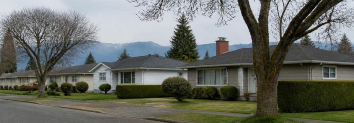
Two things get confused about Pemberton Heights, and both of them matter if you are house-hunting. The first is the name. Pemberton Avenue, down by the water, is a working commercial strip in the City of North Vancouver. Pemberton Heights is something else entirely: a quiet residential plateau above Marine Drive, in the District.
The second is the creek. Guides pair this neighbourhood with Mosquito Creek. The District’s own study of the area names a different one: “Highway 1 is to the north, McKay Creek to the east, and Barbour Park escarpment to the south and west.” Mosquito Creek is further east again.
What makes Pemberton Heights genuinely unusual is something no other article mentions. It is the only neighbourhood in the District of North Vancouver with a residential zone written for it by name, and the rules in that zone are why the streets look the way they do.
The short version
- It is in the District of North Vancouver, not the City. The Province’s own place-name record puts it “In North Vancouver District Municipality, E of Capilano River S of (below) Highway 1”.
- It has its own zone. The Single Family Residential Pemberton Heights Zone, RSPH, exists to “maintain the single-family character” of the properties in it. Front and rear yard minimums are 7.62 metres, or 25 feet — deep for a North Shore single-family zone.
- Two ways in, and that is the whole story of the traffic. The District records vehicle access “from two points”: Capilano Drive at Keith Road by the Highway 1 on-ramp, and West Keith Road via MacKay Avenue.
- Development here began early. A District-commissioned engineering report found that road construction and residential development at the escarpment edges “had began by 1926”.
- The escarpment has been studied, and the findings are mixed, not clear. Read the hazard section below rather than assuming either way, and look your own address up on the District’s map.
- One bus runs through it. The 236 Grouse Mountain/Lonsdale Quay goes along MacKay Avenue and West 22nd Street. Marine Drive and Capilano Road carry direct buses to downtown Vancouver over the Lions Gate Bridge.
- Capilano Elementary is inside the neighbourhood, at 1230 20th Street West. Confirm any catchment with the school district — no current catchment statement is published.
- There are no shops in it. Daily life happens at Lions Gate Village below, on Marine Drive, or up in Edgemont.
On this page
- Where it is, and which city hall you deal with
- A short history
- The streets, and how the neighbourhood is shaped
- The zone written for this neighbourhood by name
- The housing stock, and what drives price here
- The escarpment: what the District’s own studies found
- Which planning documents are actually in force
- Daily life, recreation and the library
- Schools
- Getting around
- What is proposed nearby
- Who it suits, and who should look elsewhere
Where it is, and which city hall you deal with
Pemberton Heights sits east of the Capilano River and below Highway 1, on the plateau above Marine Drive. It is one of the District of North Vancouver’s named neighbourhoods and appears on the District’s own neighbourhood map, published 19 September 2026 and sourced to its GIS department.
Getting the municipality right is not pedantry. The City and the District are separate governments with different bylaws, different fees and different phone numbers. Three independent sources settle it for Pemberton Heights.
BC Geographical Names, the provincial naming authority, records Pemberton Heights as an adopted official name for a community, located “In North Vancouver District Municipality, E of Capilano River S of (below) Highway 1”. The decision date on the record is 19 July 1979. That is the date the name was adopted, not the date the neighbourhood was built.
Second, a District-commissioned school safety study states plainly that Capilano Elementary “is located in the Pemberton Heights area of the DNV”. Third, the District’s zoning bylaw contains a zone that exists only for this neighbourhood, which no City bylaw could do.
The boundary, in the District’s own words from that study: “Highway 1 is to the north, McKay Creek to the east, and Barbour Park escarpment to the south and west.” A separate District report describes the escarpment as lying “east of Capilano River, north of Marine Drive, and south of West Keith Road”.
Who to call. The District of North Vancouver is at 355 West Queens Road, North Vancouver. The main line is 604-990-2311. Building and permits is 604-990-2480, or building@dnv.org. Anything municipal can change, so call before you rely on it — and call again before you commit money.
A short history
The best-sourced date for this neighbourhood comes from an unlikely place: a geotechnical report. BGC Engineering Inc., writing for the District in November 2008, examined aerial photographs of the escarpment and concluded that road construction and residential development at the top and bottom of it “had began by 1926”. The grammatical slip is the report’s own.
That fits the wider Capilano story. The District’s 1993 Heritage Inventory describes how “The Capilano River dominates this neighbourhood, and inspired its initial development as a recreational area”, notes that the “extension of the streetcar line to Lower Capilano shortly before World War I initiated suburban residential development”, and records that “The Lions Gate Bridge opened in 1938, making Upper and Lower Capilano even more easily accessible from Vancouver.”
Where does the name come from? According to the North Shore Heritage Preservation Society, a local heritage group, it traces back to the Lonsdale Estates, which “bought up large areas of North Vancouver that became streets with Lonsdale family-associated names. Examples include Fell Avenue, Pemberton Avenue, Pemberton Heights and Heywood Park”. The society also attributes Bridgman Park to Edward Harry Bridgman, the Lonsdale Estates office manager.
I am attributing that rather than stating it, deliberately. BC Geographical Names holds no origin note for Pemberton Heights, and the heritage society is the only source I could find for the story. Take it as what that society says, not as a settled fact.
Two things often repeated about this area I am leaving out, because I could not verify them twice: a subdivision date, and the name of whoever subdivided it. Neither appears in any District document or provincial record I could open.
The streets, and how the neighbourhood is shaped
The streets the District’s own study names inside Pemberton Heights are 20th Street West, 21st Street West, West 22nd Street, West 23rd Street, Bridgman Avenue, Pemberton Avenue, MacKay Avenue, Capilano Drive, West Keith Road, Hope Road, Lloyd Avenue and Cortell Street.
The shape of the place is set by one fact more than any other. The District records that “Vehicle access into the neighbourhood is from two points: the Capilano Drive and Route 1 East/Keith Road intersection (at the Highway 1 eastbound on ramp) to the northwest and West Keith Road via MacKay Avenue in the southeast.”
Two entrances, bounded by a highway on one side and an escarpment on the other, is why there is no through traffic here. It is also why a closure or construction at either entrance is felt by everyone. Residents of a grid with six ways out never notice roadworks. Residents here do.
On walkability, the District’s study is measured rather than enthusiastic: “Sidewalks are generally in good condition with some form of curb drop. Total width of sidewalks averages 1.5m but there are some locations narrowed by vegetation encroachment.” It describes the surrounding area as “predominantly a suburban residential community”.
The zone written for this neighbourhood by name
This is the thing to understand about Pemberton Heights, and it is in no other guide to the area.
The District’s zoning bylaw contains a Single Family Residential Pemberton Heights Zone, short form RSPH, established by Bylaw 7006. Its stated purpose is explicit: “The intent of the RSPH Zone is to establish development regulations to maintain the single-family character of all properties zoned RSPH as identified on Map 509, Schedule ‘A’.”
Most District neighbourhoods are zoned RS1 to RS5, the standard single-family zones. A handful have their own. Pemberton Heights is one of them, and the numbers in its zone are what give the streets their spacing.
| RSPH zone rule | What the bylaw requires | Why it shows on the street |
|---|---|---|
| Front yard | 7.62 m (25 ft.) minimum, for all storeys other than the upper storey | A deep, even setback from the road on every lot |
| Rear yard | 7.62 m (25 ft.) minimum | Generous back gardens, and distance between facing houses |
| Individual side yard | 1.22 m (4 ft.) minimum | The tight dimension; houses can sit close on one side |
| Combined side yards | Minimum of 20% of lot width | Scales with the lot, so wide lots keep wide gaps |
| Maximum eave height | 6.71 m (22 ft.) for all lot widths | Caps the visual bulk regardless of lot size |
| Maximum building height | 6.71 m (22 ft.) for a flat roof, rising to 9.14 m (30 ft.) for a steeper pitch on a wider lot | Rewards a pitched roof with extra height |
| Principal use | One single-family residential building | The zone’s whole purpose |
| Accessory uses | Secondary suites and coach houses, subject to conditions; home occupations; a bed and breakfast business | A house can still carry a suite and a coach house |
Read that table and the look of the neighbourhood explains itself. Twenty-five feet front and back is unusually deep for a North Shore single-family zone, and a combined side-yard rule set as a percentage of lot width means spacing grows with the lot rather than being fixed. That is a consistent streetwall, by design.
Worth knowing: the floor space ratio in this zone changes at two lot sizes, 464.5 square metres (5,000 square feet) and 1,114.8 square metres (12,000 square feet). A zone written with brackets that far apart was written for a neighbourhood with a wide range of lot sizes. What individual lots here actually measure is not published anywhere I could find, so check title and survey rather than assuming.
The housing stock, and what drives price here
Honest answer first: the District publishes no statement characterising the era of the housing stock across Pemberton Heights as a whole. The only sourced date is the 1926 finding for the escarpment edges. So rather than invent a decade breakdown, here is what is verifiable and what actually moves value on this plateau.
What drives price here is position on the plateau, outlook, lot width and how close a property sits to either the highway edge or the escarpment edge. The RSPH setbacks mean a wide lot buys you more usable separation than it would in a zone with fixed side yards, which is a real difference and not a sales point.
A house in this zone can also carry a secondary suite and a coach house, subject to the zone’s conditions. That matters to a buyer thinking about a mortgage helper or family living separately, and it is a question for the District rather than for an agent.
I do not publish price or benchmark figures on neighbourhood pages, because they are stale within weeks. The current numbers live on the North Shore real estate market statistics page.
The escarpment: what the District’s own studies found
Pemberton Heights sits on a plateau with an escarpment on its south and west edges. The District has studied that escarpment properly, and the findings deserve to be reported in full rather than selectively. They are mixed.
The study is the “Westlynn and Pemberton Heights Escarpments Landslide Risk Assessment”, by BGC Engineering Inc. for the District of North Vancouver, dated 27 November 2008. Its study area “includes the Pemberton Heights Escarpment east of Capilano River, north of Marine Drive, and south of West Keith Road”. Five properties on the Pemberton Heights escarpment were investigated.
The reassuring finding. The report states: “No evidence of historical flow slides with magnitude and runout sufficient to cause significant structural damage to homes (typically slides with a magnitude greater than 100 m3) was identified.” It also found that “No hypothetical landslide source areas investigated fall in the Unacceptable zone.”
The finding that is usually left out. The same report records that “Landslides originating from one property investigated posed unacceptable landslide risk levels to individuals at the base”. Against the District’s own interim risk tolerance criteria, the report concluded that “Based strictly on the interim risk tolerance criteria, no further mitigation is currently required”, while noting the ALARP principle, “which requires that all landslide risks be kept under review”.
Both halves are true, and a buyer deserves both. This is an eighteen-year-old study of five properties, not a clearance certificate for a neighbourhood. If the escarpment edge is anywhere near a property you are considering, that is a question for a qualified geotechnical engineer and for the District, not for a guide.
The two-minute check anyone can do
The District maps its Development Permit Areas, and you can look up any address yourself. The District’s own instruction is to use its Property Viewer at geoweb.dnv.org. Do that before you write an offer, not after.
The Slope Hazard Development Permit Area is the one most likely to matter on this plateau. The District defines a steep slope as having “a slope angle greater than 20 degrees (36%) and greater than 10 metres in height”, and the area “will apply to those properties having a boundary within 20 metres of the top or bottom of a steep slope”.
The Streamside Protection area is worth knowing here because MacKay Creek is named in it. The District’s rule reaches “Within 15 metres of the top of bank of a stream”, and separately “Within 30 metres of the top of bank of a stream for properties greater than 0.5 hectares in size, located on or adjacent to Capilano River, Lynn Creek, Seymour River, or Mackay Creek at any point south of Marine Drive”. Note both conditions on that 30-metre clause — it needs a property over half a hectare, which very few here are.
A Creek Hazard area also exists, covering “properties adjacent to creeks and rivers identified with a potential risk due to debris flow, debris flood and flood”. The District’s brochure names no individual creeks; it works off a map, which is why the address lookup is the only reliable answer. There is a Wildfire Hazard area too, covering “All properties located in the District’s forested wildland / urban interface and some District Park areas”.
One thing worth correcting, since it is easy to assume the opposite. MacKay Creek does have a debris-flow study, by Kerr Wood Leidal Associates Ltd. in December 2003, but it locates the creek “on the southwest slope of Grouse Mountain” and the properties it identifies as vulnerable are well north of here. That report does not mention Pemberton Heights anywhere.
The District’s advice on all of these is the same, and it is good advice: “If your property is included within one or more of the DPAs, discuss your proposed work with District staff early in the process.” Call 604-990-2480 or email building@dnv.org.
Which planning documents are actually in force
This is where most neighbourhood guides go wrong. They quote a plan that was rescinded years ago, or treat a consultation board as policy. Here is the honest state of play, checked on 1 October 2026.
| Document | Status as at 1 October 2026 | What it means for you |
|---|---|---|
| Official Community Plan, Bylaw 7900 | In force. The District’s bylaw page still identifies the OCP as Bylaw 7900 | This is the plan that governs. Its Development Permit Area guidelines are in Schedule B |
| Single Family Residential Pemberton Heights Zone, RSPH, Bylaw 7006 | In force. The District’s RSPH handout is dated April 2026 | These are the rules that apply to a rebuild or renovation today |
| Older local area plans | Rescinded. “These local area plans were rescinded with the adoption of the District-wide Official Community Plan (OCP). The documents on this page are for reference only.” | Interesting history. Not a rule. Do not let anyone quote one at you as current |
| Zoning Bylaw rewrite, including new R1, R2 and houseplex zones | In draft. A staff report dated 21 January 2026, considered at the Council Workshop of 10 February 2026, described the first draft as “undergoing testing and refinement” | Change is coming to District single-family zoning. The shape of it is not settled |
| Zoning Bylaw 8799, adding R1 and R2 zones | Under consideration. The District’s own schedule is headed “Bylaw Under Consideration” and dated 2 June 2026 | Not adopted. It does not mention RSPH or Pemberton Heights |
| Proposed consolidation of single-family zones | Proposal. A June 2025 staff report proposed consolidating “over 20 different zones that permit single-family developments”, and RSPH is named in that list | RSPH may not exist in its current form indefinitely. No document says what replaces it |
| OCP Update engagement material | Consultation only, from April 2025. No adopted replacement OCP could be found | See the next section. Read these as proposals, never as decisions |
If you take one thing from that table, take this: the operative plan is still the 2011 District-wide OCP, and the zone that governs your lot is still RSPH. Everything else above is in motion.
Daily life, recreation and the library
Pemberton Heights has no shopping strip of its own. No District source lists shops or businesses inside the neighbourhood, and that is not an oversight on my part — it is the character of the place. Daily errands happen below the plateau or over the ridge.
The nearest recreation is the Lions Gate Community Recreation Centre, at 1733 Lions Gate Lane, “in the heart of the new Lions Gate Village”. Its phone number is 604-983-7650. Published facility hours are Monday to Thursday 7:00 a.m. to 9:00 p.m., Friday 7:00 a.m. to 8:00 p.m., Saturday and Sunday 8:00 a.m. to 5:00 p.m., closed on statutory holidays.
North Vancouver Recreation and Culture lists what is in it: a “Full-sized gymnasium with basketball, volleyball, badminton, and pickleball”, “Multi-purpose spaces for a wide range of social, recreational and cultural activities”, an “Art studio”, community spaces “including a meeting room, ‘living’ room with comfortable seating areas, and a kitchen”, a Red Cross Health Equipment Loan Program, public art and public Wi-Fi, a District-owned public plaza with play spaces and outdoor seating, and 55 parking stalls including accessible and electric-vehicle charging.
Library service comes in two forms. The Lions Gate Express Library shares that building at 1733 Lions Gate Lane, on 604-998-3033, open Monday, Wednesday, Friday, Saturday and Sunday 10 a.m. to 5 p.m. and Tuesday and Thursday 12 p.m. to 7 p.m. For a full branch, Capilano Library is at 3045 Highland Boulevard, on 604-987-4471, open Monday 10 a.m. to 6 p.m., Tuesday to Thursday 10 a.m. to 8 p.m., and Friday to Sunday 10 a.m. to 6 p.m. It is “closed on most public holidays”. Note that Capilano Library is up in the Highland area, not in Pemberton Heights.
If you want a swimming pool, the nearest option is the Delbrook Community Recreation Centre at 851 West Queens Road, on 604-983-6530. Its facility and fitness hours are Monday to Friday 5:30 a.m. to 10:00 p.m., Saturday 7:00 a.m. to 10:00 p.m., and Sunday and statutory holidays 7:00 a.m. to 6:00 p.m.
The community association, and one thing I could not verify
There is a Pemberton Heights Community Association, and it runs real events. Its own site states that “Annual dues are $20 and can be paid in person at any Pemberton Heights event”, and that the dues support community events and activities “such as the annual Canada Day picnic”. There is also a parents’ networking group for local families.
There is a community hall. I could not confirm its street address from any primary source, so I am not printing one. The addresses circulating on business-directory websites all trace back to each other rather than to the association. Ask the association directly, or ask a neighbour.
The same honesty applies to Barbour Park, which forms the escarpment edge on the south and west. It is a named District park and it appears on District zoning maps. No District or recreation source I could open publishes its address, size or amenities, so I am not inventing them.
Schools
Capilano Elementary is inside the neighbourhood, at 1230 20th Street West, on 604.903.3370. The District’s own study notes that the school “is bordered by four roads: 21st Street West, 20th Street West, Bridgman Avenue and Pemberton Avenue”, which tells you how embedded in the streets it is.
Nearby, Norgate Xwemélch’stn Community Elementary is at 1295 Sowden Street, on 604.903.3680. For secondary, Carson Graham Secondary is at 2145 Jones Avenue, on 604.903.3555.
Do not assume a catchment from this list. I could find no current School District 44 statement assigning Pemberton Heights to any catchment, and catchments are reviewed and change. Check your own address with the district’s own tool: the SD44 School Locator. The district office is on 604-903-3444.
Getting around
One bus route runs through Pemberton Heights, and three more run along its edges. All four timetables below are the ones effective 20 April 2026.
| Route | Official name | Where it runs relative to the neighbourhood |
|---|---|---|
| 236 | Grouse Mountain/Lonsdale Quay | Through it. Runs via Marine, MacKay and 22nd Street, with a stop at 22nd Street at Philip |
| 246 | Downtown/Highland | Along the edge, via Marine Drive and Capilano Road. Direct to downtown Vancouver over the Lions Gate Bridge |
| 247 | Downtown/Grouse Mountain | Along the edge, via Marine Drive and Capilano Road to downtown Vancouver |
| 255 | Capilano University | Touches Marine Drive at its western end; runs east to Capilano University |
The 236’s own route description runs “From Lonsdale Quay via Carrie Cates Court, Rogers, W Esplanade, Forbes, 3 St, Marine, MacKay, 22 St (Pemberton Heights), Keith, Hwy 1 off-ramp, Capilano Rd, Nancy Greene Way to Grouse Mountain.” Returning, it comes back down 22nd Street and MacKay, then 17th Street and Lloyd Avenue to Marine.
For a driver, the position is genuinely good and genuinely limited at the same time. The Highway 1 on-ramp is at one of the two entrances, and the Lions Gate Bridge is a short run down Marine Drive and Capilano Road. But there are still only two ways in and out, and both feed the same two corridors.
I am not printing journey times. Two independent readings of the timetables did not agree closely enough to publish, and a wrong commute time is worse than none. Use the trip planner at translink.ca for your own address and your own departure time.
What is proposed nearby
Nothing is being built inside Pemberton Heights. No District development application sits at a Pemberton Heights address. But three things nearby are worth knowing about, and all three are proposals rather than decisions.
The OCP Update. In April 2025 the District consulted on an update to its Official Community Plan. The engagement material states that “The Province is requiring the District of North Vancouver to accommodate approximately 22,000 additional homes in the community over 20 years”, and elsewhere gives the precise provincial figure as 22,369 new homes by 2041.
Pemberton Heights is named in that material, once, and the wording matters: “Low-density multi-family housing opportunities for Norgate and Pemberton Heights neighbourhoods adjacent to the centre boundaries.” Read the qualifier. It is about land next to the centre boundaries, not the whole neighbourhood.
This has not been adopted. As at 1 October 2026 the District’s own bylaw page still identifies the Official Community Plan as Bylaw 7900, and I could find no adopted replacement. So that line is April 2025 consultation material and nothing more. Anyone telling you Pemberton Heights has been rezoned for multi-family is ahead of the documents.
Capilano Road. Chard Development Ltd. has an application for 1634 and 1748 Capilano Road, on the western approach. The District’s engagement platform describes a 12-storey hotel with 171 units and a 37-storey mixed-use commercial and residential rental building stepping down to an 11-storey wing, with 478 residential units of which 430 are market rentals and 48 below-market. The detailed application was received on 27 September 2023 and the public discussion forum is closed. I could not confirm its current status, so treat the numbers as what was applied for.
Marine Drive. The District’s page for 2050 and 2070 Marine Drive, the former Travelodge site, states that “IBI Group has applied to develop 77 market rental apartments and 158 owned apartments in a 27-storey tower with adjacent townhouses, 54 owned apartments in a nine-storey building with adjacent townhouses, and 41 non-market rental apartments in a four-storey building.” Again: applied for, present tense, status unconfirmed.
The pattern is clear enough. The District’s growth is being directed to Lions Gate Village and the Marine Drive and Capilano Road corridors, which is to say around the plateau rather than on it. Check the current position yourself on the District’s development applications page, or call 604-990-2311.
What locals like, and what they complain about
The likes follow from the geography. Two entrances mean no through traffic. A zone built to “maintain the single-family character” means the street you buy on is likely to look much the same in ten years. An elementary school sits inside the neighbourhood. The Highway 1 on-ramp and the Lions Gate Bridge are both close.
The complaints follow from the same geography, and it is only fair to name them. Highway 1 runs along the northern edge, and a highway is a noise source. Two entrances become a single point of frustration when either one is dug up. There are no shops, so every errand is a drive or a bus. And the escarpment edge brings a development permit process with it for anyone wanting to build.
One more, and it is the honest one for 2026: District single-family zoning is in the middle of a rewrite, RSPH is on the list of zones proposed for consolidation, and no document says what will replace it. If certainty about future zoning is what you are buying, nobody can sell it to you here right now.
Who it suits, and who should look elsewhere
It suits you if you want a quiet detached street with no through traffic, you drive or bus to the city and value being minutes from both the highway and the bridge, you have primary-age children and like the idea of a school inside the neighbourhood, and you want deep setbacks and spacing rather than the densest possible use of a lot.
Look elsewhere if you want to walk to shops, cafés and a grocery store — Edgemont Village or Central Lonsdale will suit you far better. Also look elsewhere if you want apartment or townhouse living, since this is a single-family zone; if highway noise is something you cannot settle with, because the northern edge has it; or if you want to build something substantial on the escarpment side without a geotechnical process.
If you are weighing it against the neighbouring areas, the honest comparison is this. Edgemont gives you a village to walk to and no highway edge. Lions Gate Village gives you the recreation centre and the library on your doorstep and apartment living. Pemberton Heights gives you the quietest streets of the three and the least to walk to.
If you are buying on the North Shore generally, there is more on the process in my guides.
Thinking about a move here?
Send me an address on any of these streets and I will tell you what the District’s map says about it — which development permit areas touch the lot, what RSPH allows on it, and what the permit history shows. That is a more useful conversation than a list of features.
Thinking about buying or selling in Pemberton Heights?
Leave your name and number and I will come back to you, usually the same day. Tell me the address if you have one and I will pull the sale history and the documents that matter before we talk. No charge, no obligation.
Prefer to talk now? Call or text 778-903-7306.
Strata buildings near Pemberton Heights
The 12 closest of 41 buildings on my list. Each page shows the homes for sale there right now.
Read next
- Edgemont Village, North Vancouver: a buyer’s guide
- Upper Lonsdale, North Vancouver: a buyer’s guide
- Central Lonsdale, North Vancouver: a buyer’s guide
- Lynn Creek Town Centre, North Vancouver: a buyer’s guide
- How many homes can you build on a North Vancouver lot?
- All North Shore neighbourhood and buyer guides
این راهنما را به فارسی بخوانید — Read this guide in Farsi
Disclaimer: this guide is general information about Pemberton Heights and is not advice on any specific property. Zoning rules, development permit area boundaries, bylaws, planning status, school catchments, bus routes, facility hours and municipal fees all change, sometimes without notice. Every fact here was verified against its primary source on 1 October 2026, and several items were deliberately left out because I could not verify them twice — a subdivision date, Barbour Park’s address, and the community hall’s address among them. Anything municipal must be confirmed with the authority that owns it: the District of North Vancouver on 604-990-2311, or building and permits on 604-990-2480 or building@dnv.org, for zoning, development permit areas and permit history; School District 44 on 604-903-3444 and the SD44 School Locator for catchments; TransLink for routes and times; and North Vancouver Recreation and Culture and the North Vancouver District Public Library for facility hours. Look your own address up on the District’s property viewer at geoweb.dnv.org before you rely on anything here, and take professional advice — including from a qualified geotechnical engineer where slope or creek hazards may apply — before you commit money. Last reviewed: October 2026.
Run your Pemberton Heights numbers before you make an offer
Three figures decide what you can actually buy here, and all three use 2026 BC rates.
- Mortgage and stress test — what a lender will actually approve
- Property transfer tax — 2026 rates and the exemptions
- Closing costs — what you need on top of the deposit

Tom Jahed, REALTOR®
Vanak Realty, North Vancouver. Ten years in North Vancouver real estate and more than 400 transactions closed, including pre-sales. Works in English and Farsi.
Written by Tom Jahed, licensed REALTOR®, Vanak Realty, North Vancouver.