
این صفحه را به فارسی بخوانید (Farsi)
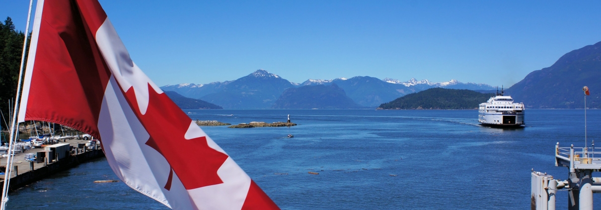
Horseshoe Bay is two places at once. It is a small village on a sheltered bay, with a park, a marina and a few streets of shops. It is also the terminal for three BC Ferries routes and the start of the Sea-to-Sky Highway, so a great deal of traffic passes through it on its way somewhere else.
Living here means accepting both. This guide covers what the District has planned for the village, what the ferry terminal renewal means for the next few years, the rules that decide what you can build, and the practical things, like how a moving truck gets in, that people only find out after they buy.
Call them before you rely on anything here
Rules, catchments and bus routes change, sometimes with little notice. Everything on this page is subject to change. Phone or email the people who decide before you write an offer. Last reviewed 2 October 2026.
- District of West Vancouver, Municipal Hall, 750 17th Street: 604-925-7000, info@westvancouver.ca, 8:30 a.m. to 4:30 p.m. weekdays (contact page)
- Planning and Development Services (zoning, development permits, heritage): 604-925-7055
- Permits and Inspections: 604-925-7040
- West Vancouver Schools (which school serves an address): 604-981-1000
- BC Ferries, for terminal and booking questions: bcferries.com
The short version
- Where: the Archives describe Horseshoe Bay as roughly the area from the western slope of Black Mountain to Madrona Crescent, and from Gleneagles Golf Course to Howe Sound.
- Ferries: Route 2 to Nanaimo (Departure Bay), Route 3 to Langdale and Route 8 to Bowen Island (Snug Cove). Every vehicle going to Departure Bay must book ahead.
- The terminal is being rebuilt: a multi-year BC Ferries renewal costing hundreds of millions, with vehicle space inside the terminal reduced during construction. BC Ferries reported in June 2026 that several staging lanes had returned to regular use, so check its service notices for the current layout.
- The village plan: the Horseshoe Bay Local Area Plan, adopted on 1 June 2021, plans for 200 to 300 net new homes, mostly in two- to four-storey buildings.
- Schools: Gleneagles Ch’axáý Elementary takes students from Horseshoe Bay. Confirm the catchment for the exact address on 604-981-1000.
- Bus: TransLink routes 250 and 257 Express to downtown Vancouver.
On this page
- Where it is
- The ferries, and the terminal renewal
- Traffic, the highway and moving trucks
- The village plan: what can be built
- Trees, shoreline, wildfire and the 2026 housing changes
- Whytecliff Park, the bay and the marina
- Schools
- Getting around
- What to check before you buy in Horseshoe Bay
- Sources
Where it is
The West Vancouver Archives describe Horseshoe Bay as roughly the area from the western slope of Black Mountain in the east to Madrona Crescent and the height of land in the west, and from Gleneagles Golf Course in the south to Howe Sound in the north. The name came from early summer visitors, because the bay is roughly the shape of a horseshoe.
The village core is a handful of streets. The District’s plan gives particular design guidance to Bay, Royal, Little Bay, Keith and Nelson, the streets that carry the shops, the park and the walk to the ferry.
Everything municipal goes to the District of West Vancouver at 750 17th Street: 604-925-7000. Planning is 604-925-7055.
The ferries, and the terminal renewal
Horseshoe Bay has three ferry routes under the Province’s contract with BC Ferries: Route 2 to Nanaimo, Route 3 to Langdale on the Sunshine Coast, and Route 8 to Snug Cove on Bowen Island (coastal ferry services contract). On the Nanaimo route, BC Ferries says advance booking remains required for all vehicles travelling from Horseshoe Bay to Departure Bay. BC Ferries announced in May 2025 that drive-up fares on that route would end.
The terminal itself is in the middle of a long rebuild. BC Ferries describes the work as upgrading or replacing three berths, relocating the control tower, upgrading aged elevated structures, and enhancing seismic resiliency, and expects the total cost to be in the hundreds of millions. In June 2026 BC Ferries reported a major milestone and said the remaining work was scheduled to recommence following the busy summer season.
For residents, the number that matters is space. During construction, vehicle space inside the terminal was reduced by about 25 per cent, and BC Ferries said in 2025 that overall vehicle space would remain below current levels for several years.
Traffic, the highway and moving trucks
Horseshoe Bay is where Highway 99, the Sea-to-Sky, begins: the Province lists kilometre 0.0 as the off-ramp from Highway 1 (highway exits). The Province’s own corridor study says that eastbound Highway 99 merging with Highway 1 traffic from the ferry terminal is challenging, and that peak ferry days tend to be peak days on the Sea-to-Sky too.
The ferry also shapes the village streets. When the District looked at routing the Spirit Trail through the village, an option that took a traffic lane was rejected as an option by BC Ferries because it would have delayed ferry offloading.
One detail worth knowing before moving day: heavy vehicles, which the District defines as over 11,800 kg gross vehicle weight, may only reach Horseshoe Bay Village by the District’s set heavy vehicle route, via Exit 3 from Highway 1/99 westbound. The District warns that heavy vehicles will get stuck at the Nelson Avenue roundabout and are not permitted to use Nelson Avenue northbound from Marine Drive to Chatham Street. If your mover is sending a large truck, give them that rule along with the address.
The village plan: what can be built
On 1 June 2021, Council adopted the Horseshoe Bay Local Area Plan and Design Guidelines as part of the Official Community Plan. The plan confirms the gradual addition of 200 to 300 net new homes, and its height limits favour low-rise buildings of two to four storeys that step down the slope, with only two small exceptions (Local Area Plan).
In December 2021 the District followed with Bylaw 5155, which added neighbourhood residential zones in Horseshoe Bay: infill (RG-1A and RG-1B), multiplex (RG-2) and rowhouse (RG-3). The Horseshoe Bay Neighbourhood Centre also has its own form-and-character guidelines for new buildings, additions and renovations.
What this means for a buyer: the village is expected to add homes slowly and stay low. If you are buying a lot or an older house for what could be built on it, ask Planning on 604-925-7055 which zone applies to that address and what the plan allows there, before you pay for potential.
Trees, shoreline, wildfire and the 2026 housing changes
- Shoreline: a Foreshore development permit is required for work on waterfront property or other property at risk of coastal flooding (hazard development permit areas).
- Wildfire: a Wildfire Hazard development permit is required for work within 100 metres of an undisturbed forest interface. Check the lot on WestMap.
- Creeks: an Environmental development permit is required for work within 15 metres of the top of any watercourse bank.
- Trees: any tree 75 cm in diameter or more is protected, and so are arbutus, Garry oak, Pacific yew, Pacific dogwood, yellow cedar and shore pine above 20 cm (Tree Bylaw). On a lot being redeveloped, any tree 20 cm or more is protected.
- Small-scale multi-unit housing: West Vancouver’s rules took effect with Bylaw 5351 on 12 August 2024. A follow-up bylaw had third reading on 21 September 2026 and has not been adopted while it waits for provincial approval (District of West Vancouver).
Whytecliff Park, the bay and the marina
Whytecliff Park is at the end of the 7000 block of Marine Drive, just west of the village, and covers more than 15 hectares. The District bought it from Union Steamships for $75,000 and dedicated it as a park by bylaw in 1953, and in 1993 the waters off it became Canada’s first Saltwater Marine Protected Area. Fisheries and Oceans Canada lists it as closed to fishing for finfish, shellfish, crab and other invertebrates.
In the village, Horseshoe Bay Park is a one-hectare waterfront park between Sewell’s Marina to the north and the ferry terminal to the east.
Schools
West Vancouver Schools says Gleneagles Ch’axáý Elementary sits at the western point of West Vancouver and includes students from Horseshoe Bay, Lions Bay and Eagle Harbour. I could not confirm from a primary source which secondary school serves Horseshoe Bay addresses, so ask.
The board office is at 1075 21st Street, and the main line is 604-981-1000. Confirm the catchment for the exact address before you remove subjects.
Getting around
- Route 250 Horseshoe Bay/Dundarave/Vancouver: along Marine Drive and over the Lions Gate Bridge to downtown.
- Route 257 Horseshoe Bay/Vancouver Express: the express service to downtown.
- By car: Highway 1 east to the bridges, or Highway 99 north to Squamish and Whistler.
- By ferry: Nanaimo, Langdale and Bowen Island from the terminal.
What to check before you buy in Horseshoe Bay
- How the ferry and highway traffic reaches the street you are looking at, on a summer Friday as well as a weekday.
- Which zone applies to the address and what the Local Area Plan allows there, from Planning on 604-925-7055.
- For waterfront, whether the lot is in the Foreshore development permit area; for a lot near the forest, whether it is in the Wildfire Hazard area.
- For a condo or townhouse, the depreciation report and strata minutes. How to read them.
- The permit history for the house. How to check it.
- The heavy vehicle route, before you book a moving truck.
- The catchment schools for the exact address, from West Vancouver Schools on 604-981-1000.
Strata buildings near Horseshoe Bay
Each page shows the homes for sale there right now.
Read next
- Caulfeild, the neighbourhood to the east
- What it costs to buy a home in West Vancouver
- Every home for sale in West Vancouver, live from MLS®
- All of Tom’s North Shore guides
Sources
- West Vancouver Archives, Horseshoe Bay. Checked 2 October 2026.
- District of West Vancouver, Horseshoe Bay Local Area Plan. Checked 2 October 2026.
- District of West Vancouver, Local Area Plan and Design Guidelines. Checked 2 October 2026.
- District of West Vancouver, zoning bylaw amendments. Checked 2 October 2026.
- District of West Vancouver, heavy vehicle routes. Checked 2 October 2026.
- BC Ferries, Horseshoe Bay terminal renewal, February 2025. Checked 2 October 2026.
- BC Ferries, construction and booking changes, May 2025. Checked 2 October 2026.
- BC Ferries, infrastructure milestone, June 2026. Checked 2 October 2026.
- Province of BC, highway exits. Checked 2 October 2026.
- Province of BC, Highway 1/99 North Shore corridor study. Checked 2 October 2026.
- District of West Vancouver, Whytecliff Park. Checked 2 October 2026.
- West Vancouver Schools, Gleneagles Elementary. Checked 2 October 2026.
- TransLink, route 257. Checked 2 October 2026.
Before you act: call the District on 604-925-7000 and West Vancouver Schools on 604-981-1000 with the exact address, and check BC Ferries for the current terminal arrangements. The information on this page is subject to change.
Disclaimer. This page is general information about a neighbourhood, not advice about a specific property, and nothing on it is legal, tax or financial advice. Zoning, development permit areas, heritage rules, school catchments, bus routes, ferry arrangements and park rules all change, sometimes with little notice. Every fact here was checked against the source linked beside it on 2 October 2026; last reviewed 2 October 2026, next review January 2027. Before you rely on anything on this page, confirm the current position with the District of West Vancouver at 604-925-7000 or info@westvancouver.ca, West Vancouver Schools at 604-981-1000, and TransLink for routes and times. Take independent legal, tax and financial advice before committing money to a purchase or a sale.
Run your Horseshoe Bay numbers before you make an offer
Three figures decide what you can actually buy here, and all three use 2026 BC rates.
- Mortgage and stress test — what a lender will actually approve
- Property transfer tax — 2026 rates and the exemptions
- Closing costs — what you need on top of the deposit
Tom Jahed, REALTOR®
Vanak Realty, North Vancouver. Ten years in North Vancouver real estate and more than 400 transactions closed, including pre-sales. Works in English and Farsi.
Written by Tom Jahed, licensed REALTOR®, Vanak Realty, North Vancouver.