
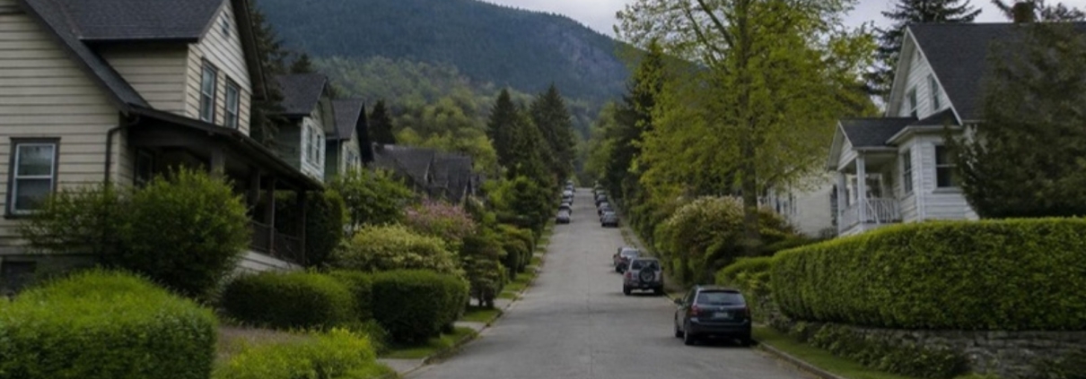
Upper Lonsdale is the top third of the Lonsdale hill in North Vancouver, above the shops and towers of Central Lonsdale and below the forest. Most people describe it as a quiet residential area with a short shopping strip, big trees, steep side streets and a view south over the harbour. That part is easy.
The part that surprises buyers is that Upper Lonsdale is not one place, legally. Part of it belongs to the City of North Vancouver and part of it belongs to the District of North Vancouver. They are two separate local governments with two sets of bylaws, two planning departments and two phone numbers. Which one you deal with depends on which side of the line your address sits.
This guide covers what the area is made of, what the slope and the creeks mean for building on it, what is actually on the shopping strip, how long the buses really take, and the questions worth asking before you write an offer. Every number here was checked against the source that owns it, and each source is linked.
The short version
- Two city halls. Part of Upper Lonsdale is City of North Vancouver, part is District of North Vancouver. Confirm which one owns your address before you rely on any bylaw.
- Mostly houses, with apartments on the avenue itself. Lonsdale Avenue carries the low-rise apartment buildings and the rezoning applications. The side streets are detached houses.
- The land comes with rules. Steep slope, creek and wildfire permit areas apply on the District side, and streamside rules apply on the City side. They can decide what you are allowed to build.
- The strip is small and independent. A grocery, a pub with a cold beer and wine store and a few services near Queens Road. Anything larger is downhill in Central Lonsdale.
- Transit is genuinely good for a hillside. Four routes touch the area, including a direct bus to downtown Vancouver that does not use the SeaBus.
- The new Harry Jerome Community Recreation Centre opened in July 2026 at the bottom of the hill, and the rebuilt Silver Harbour seniors’ centre opened beside it.
- No neighbourhood plan. The City has no area plan for Upper Lonsdale, so density is decided one application at a time.
On this page
- Where it is, and which city hall you deal with
- How it grew: a streetcar suburb that lost its streetcar
- The pockets, and how they differ
- What kind of money Upper Lonsdale is
- The housing stock by era, and what goes wrong with each
- Slope, creeks and wildfire: the rules that come with this land
- Daily life: what is actually on the strip
- Parks, trails and recreation
- Schools
- Getting around, with real scheduled times
- What is being built and planned
- What locals like, and what they complain about
- Who it suits, and who should look elsewhere
- Short answers to common questions
Where it is, and which city hall you deal with
Upper Lonsdale has no official boundary. It is a name people use, and the name is used by institutions too: TransLink calls one of its buses 230 Upper Lonsdale/Lonsdale Quay, and the District of North Vancouver groups its services for the area under “Delbrook / Upper Lonsdale”.
In practice people mean Lonsdale Avenue from about 21st Street up to Queens Road and Osborne Road, plus the streets on either side, running west toward Mosquito Creek and east toward Grand Boulevard.
Somewhere in that stretch the municipal boundary crosses the hill. Below it you are in the City of North Vancouver. Above it you are in the District of North Vancouver, in the area the District’s North Lonsdale–Delbrook Official Community Plan covers. That plan defines its own area as bounded by “the municipal boundary between the City and District of North Vancouver on the south” and “Mosquito Creek on the west”.
Here is the honest position on where that line runs: no municipal page or document states the street. The evidence points to 29th Street. The District’s plan designates land on the north side of West 29th Street and never the south side, and the City’s live development applications run up the Lonsdale frontage into the 2700 block. The City’s own page on the East 29th Street safety improvements says the road “is a key east-west arterial route that is shared by both the City and District of North Vancouver”, which is what two municipalities say about a shared edge. That is inference, not a statement, so treat it as a strong hint and confirm your specific address.
This matters more than it sounds. Zoning, permit rules, hazard development permit areas, garbage collection and property tax all differ between the two. A rule you read on one website may simply not apply to your house.
| Government | Hall | Phone | Planning contact |
|---|---|---|---|
| City of North Vancouver | 141 West 14th Street | 604-985-7761 | planning@cnv.org |
| District of North Vancouver | 355 West Queens Road | 604-990-2311 | District contact page |
Both addresses and numbers come from the halls’ own contact pages: the City of North Vancouver and the District of North Vancouver. Call before you count on anything. Bylaws change.
How it grew: a streetcar suburb that lost its streetcar
Upper Lonsdale exists in the shape it does because of a tram. In early September 1906 the British Columbia Electric Railway started the first streetcar line on the North Shore, running up Lonsdale Avenue from the ferry wharf. According to MONOVA, the Museum and Archives of North Vancouver, the No. 1 line first ran “north from the ferry wharf to 12th Street (later to Windsor Road)”.
Windsor Road is near the top of the hill. That extension is why houses march so far up a slope that would otherwise have been awkward to reach, and why the street grid is tightest along the avenue itself.
The same MONOVA record says “the last streetcar run in North Vancouver was made on April 27, 1947”. The buses that replaced it still follow much the same spine.
On the eastern edge, Grand Boulevard came out of the same land boom and is now on the Canadian Register of Historic Places. That record says planning was “initiated in 1906 by the North Vancouver Land and Improvement Company”, that construction began in 1908, and that after the San Francisco earthquake fires of that year, “Grand Boulevard was laid out as a generous fire break”. The central green is 105 metres wide and 1.6 kilometres long. An original covenant required that “residences must cost more than $4,000 to construct”, which is why the houses along it are large and old.
The other date that shaped the area is the Upper Levels Highway, which cuts across the slope just above the residential streets. MONOVA’s timeline records that on 4 March 1961, Premier W. A. C. Bennett opened it between the Second Narrows Bridge and Taylor Way. Worth a caveat: MONOVA is the official municipal archive, but it is the only source found for that exact date, and at least one unofficial highway history gives a different year. Treat the date as MONOVA’s, not as settled.
The pockets, and how they differ
Upper Lonsdale reads as one neighbourhood from the car, but it splits into a handful of pockets that behave differently when you buy.
The avenue itself
Lonsdale Avenue above 21st Street carries almost all of the area’s apartment buildings, and almost all of its rezoning applications. If you are buying an apartment in Upper Lonsdale, you are most likely buying on or within a block of this street. It is also the noisiest address in the area, because it is the bus spine.
The Braemar and Osborne loop, above the boundary
Above Osborne Road the streets stop being a grid. Princess Avenue, Braemar Road, Rockland Road, Prospect Road, Balmoral Road and Carisbrooke curve along the contour, and the 230 and 241 buses loop through them. These are District of North Vancouver addresses. Lots are generally larger, slopes are steeper, and the view south improves with every block of elevation.
The Grand Boulevard edge, east
East of Lonsdale the land falls toward Grand Boulevard, the heritage green corridor described above. The City’s own parks record notes Grand Boulevard Park is “part of the larger trail system known as the Green Necklace”. Housing here skews older and larger, and a heritage context comes with it.
The Mosquito Creek edge, west
West of the avenue the land runs toward the Mosquito Creek ravine, which the District’s plan names as the western boundary of its planning area. Ravine-edge lots are quiet and green, and they are the lots most likely to attract a streamside or slope requirement. See the hazard section below before you fall in love with one.
The Queens Road cross-slope
Queens Road runs east to west across the top of the area. The District’s 1995 plan calls it “the principal east-west link from Queensdale to Delbrook, Capilano Highlands and Edgemont Village”, and the 232 bus follows it. If you work or have family on the western North Shore, living near Queens Road changes your daily drive more than living one street higher or lower does.
What kind of money Upper Lonsdale is
In plain terms: Upper Lonsdale is an established, mid-to-upper North Shore house market with a much more accessible apartment market attached to it along the avenue.
A detached house here generally costs less than the equivalent house in Edgemont or the waterfront parts of West Vancouver, and more than an equivalent house further east toward Lynn Valley. Apartments on the avenue are among the more reachable ways to own on this side of the harbour, partly because many of the buildings are older and smaller.
Rather than print figures here that go stale within weeks, the current benchmark numbers for North Vancouver live on one page and are refreshed against the monthly release from Greater Vancouver REALTORS®: North Shore real estate market statistics.
What decides the price on one street and not the next
- Elevation and what you can see from it. On a south-facing hill, the view is the single loudest variable. Two similar houses three blocks apart can be very different prices.
- Which way the lot slopes. A lot that falls away to the south is a view lot. A lot that rises behind the house is a retaining-wall problem.
- Walking distance to the strip and the bus. Being able to walk to a grocery store on a hill is worth real money.
- Whether the land carries a hazard permit area. A slope, creek or wildfire designation restricts what a buyer after you can build, and buyers price that in.
- Street noise. Lonsdale Avenue, Queens Road and 29th Street carry traffic. The streets between them do not.
- Lot width and what the current rules allow on it. See the section on what is being built, below.
The housing stock by era, and what goes wrong with each
Upper Lonsdale was built in waves, and each wave brought its own repair bill. This is general guidance about building types, not a comment on any particular home. Only an inspection of the actual house tells you anything.
Pre-1940 houses, mostly east and low on the hill
Character houses of this era typically have small original foundations, old drainage and original wiring unless it has been replaced. Ask when the electrical service was last upgraded, whether the perimeter drain tile has been replaced, and whether there is a buried oil tank. Oil tanks are common in houses of this age across the North Shore and finding one is a costly surprise after closing, not before.
1950s and 1960s bungalows and split-levels
The largest single layer of housing on the hill. Common items: original single-pane windows, limited insulation, aluminum branch wiring in some homes of the era, cast-iron or clay drainage lines reaching the end of their life, and basements that were finished later without permits. Ask for permit history on any finished basement.
1970s and 1980s houses and low-rise apartments
Polybutylene supply piping appears in homes of this period and is worth identifying. In apartment buildings of this age, the questions that matter are the building envelope history, the age of the roof, the state of the plumbing risers, and what the depreciation report says is coming. Read the depreciation report, the last two years of strata minutes and the current strata insurance summary before you remove subjects.
1990s onward, and new infill
Newer buildings shift the question from repairs to rules: what the strata bylaws allow, what the contingency reserve holds, and for a new house, whether the warranty is still in force and who holds it.
Whatever the era, the City and District both keep permit records, and pulling them is one of the cheapest checks a buyer can do. There is a step-by-step guide here: how to check a property’s permit history in North and West Vancouver.
Slope, creeks and wildfire: the rules that come with this land
This is the part of an Upper Lonsdale purchase that most surprises people moving from flat ground. The hill, the ravines and the forest above all carry development permit requirements, and they can decide whether a plan is possible at all.
Steep slope, on the District side
The District’s Slope Hazard Development Permit Area “applies to those properties that are within 20 metres of the top or bottom of a steep slope”, where a steep slope means “a slope with an angle greater than 20 degrees (36%) and greater than 10 metres in height”. Note that it is the top or the bottom. Being below a bank counts.
Creeks, on the District side
The District’s Creek Hazard Development Permit Area covers properties near creeks and rivers at risk from debris flow, debris flood and flooding. The brochure does not name individual creeks, so whether it catches a specific lot is an address-by-address question for District staff.
Wildfire, on the District side
The District’s Wildfire Hazard Development Permit Area covers properties in the forested wildland–urban interface. Where it applies and you are building a new or replacement house, you need “a signed report by a qualified professional”, and the rules require that “within the defensible 1.5m space immediately surrounding the house, is a designated fuel free area (no flammable materials or landscaping)”.
Streamside setbacks, on the City side
The City’s streamside development permit guidelines exempt work “occurring more than 15 metres from the top of watercourse bank or edge of wetland (10 metres from top of ravine bank)”. Inside those distances, you need a permit. Near the Mosquito Creek ravine, that is a live question.
One practical consequence worth knowing: the District says it applies exemptions from the new small-scale housing rules for properties affected by natural hazards. On a hill full of hazard areas, a lot that looks eligible for extra units on paper may not be.
None of this is a reason to avoid the area. It is a reason to ask the right question early: which permit areas touch this address? Both halls will tell you, and the answer costs nothing.
Daily life: what is actually on the strip
Upper Lonsdale’s shopping is small, local and independent. There is no mall, no chain supermarket on the avenue and, as far as the public record shows, no business improvement association covering the upper stretch. These are the anchors that could be verified at each business’s own source:
- Queensdale Market, 3030 Lonsdale Avenue. The area’s grocery store: an independent full-service market with produce, meat, bakery, deli and dairy counters. This is the reason a lot of Upper Lonsdale households do not drive down the hill for a weekday shop.
- Queens Cross Pub, 2989 Lonsdale Avenue. A neighbourhood pub with an attached cold beer and wine store, which is the closest liquor retail to most of the area.
- London Drugs, 2032 Lonsdale Avenue. Pharmacy, post office counter and general goods. It sits at the very bottom of the stretch and most locals think of it as Central Lonsdale, but it is the nearest pharmacy of its size.
Beyond those, the strip is a mix of small services that change hands over time, so this guide does not list them. For a bank branch, a large supermarket, the main library or a big-box store, you go down the hill into Central or Lower Lonsdale. Store hours change; check before you drive.
Parks, trails and recreation
For a residential hillside, the recreation around Upper Lonsdale is unusually strong, and most of it changed for the better in 2026.
The new Harry Jerome Community Recreation Centre
The City opened the new Harry Jerome Community Recreation Centre on 25 July 2026 at 130 East 23rd Street, a short way down the hill. It includes “a 25-metre, 10-lane lap pool”, a leisure pool “with a lazy river, spray features and toddler play area”, and an NHL-sized arena “with seating for up to 500 spectators”, plus a gymnasium, fitness areas, an art studio and youth spaces.
One caveat that matters if you are moving for the pool: as of the most recent statement from North Vancouver Recreation & Culture, “the aquatic area and changerooms are not quite yet ready for use”, while the rest of the building is open. The same page says the aquatics facility “is expected to be ready for programming and lessons this fall”. Check the current status before you count on it.
Delbrook Community Recreation Centre
On the District side, Delbrook Community Recreation Centre at 851 West Queens Road has a 25-metre six-lane pool, a leisure pool with zero-depth entry and a current channel, a fitness centre, squash courts, a pottery studio and a gym set up for badminton, basketball, pickleball, volleyball and indoor soccer. For anyone living above the boundary, this is the closer of the two.
Silver Harbour
The rebuilt Silver Harbour Seniors’ Activity Centre at 2325 St Georges Avenue is open, running programs for adults aged 55 and over. Its own site says: “Our new building is now open! Come visit us Mon to Fri, 9 am to 4 pm.”
Parks and green routes
- The Green Necklace. The City describes it as “an urban greenway that forms a 7.5km scenic loop around our City centre”, built as an off-street multi-use path. It is the reason you can walk or cycle a long way here without sharing a lane with traffic.
- Grand Boulevard Park, the heritage green corridor on the east side, which the City’s own park record confirms is part of the Green Necklace.
- Mahon Park, 1601 Forbes Avenue, west of the avenue: one of the City’s oldest and largest parks, with an artificial turf field, a rubber-surfaced recreation track at Fen Burdett Stadium, a playground, a splash park, sport courts, a skateboard plaza, a leash-optional dog area and ravine walking trails.
- Loutet Park, 1700 Rufus Avenue: three grass sports fields and the Urban Farm at Loutet Park, which the City runs with the Edible Garden Project. Note for parents comparing fields: Loutet’s fields are grass, not turf.
- Mosquito Creek trail. North Vancouver Recreation & Culture’s upper Mosquito Creek walking route starts at Delbrook Community Recreation Centre and follows the creek to the Montroyal overpass stairs. It describes a gravel pathway with “some loose stone that can be uneven in places”, a slight to moderate grade, and salmon habitat along the way.
Libraries
The North Vancouver City Library is a single building at 120 14th Street West, telephone 604-998-3450. It has no branches. Households above the municipal boundary are served by the North Vancouver District Public Library, whose five locations include Capilano Library at 3045 Highland Boulevard and Lynn Valley Library at 1277 Lynn Valley Road.
Schools
Start with the caveat, because it is the one that costs families money: catchments are set by address, they change, and no guide can tell you which school your house attends. The North Vancouver School District says to “refer to the School Locator and enter your residence to determine your school catchment area”, and that where the map and the Locator disagree, the Locator wins. Check your exact address here: SD44 School Locator.
These are the public schools in and around Upper Lonsdale, with addresses as the district publishes them:
- Queensbury Elementary, 2020 Moody Ave
- Ridgeway Elementary, 420 8th Street East
- Westview Elementary, 641 17th Street West
- École Larson Elementary, 2605 Larson Rd
- École Braemar Elementary, 3600 Mahon Ave
- Queen Mary Community Elementary, 230 Keith Road West
- Carson Graham Secondary, 2145 Jones Ave
- Sutherland Secondary, 1860 Sutherland Ave
Two programme facts that matter when families compare the hill to other North Shore areas, both from the district’s own pages:
- A complete International Baccalaureate pathway runs through this area. SD44 offers the IB Primary Years Programme at Queen Mary Community Elementary (also at Capilano and Norgate), and both the Middle Years Programme and the Diploma Programme at Carson Graham Secondary. Very few Metro Vancouver neighbourhoods have the whole sequence this close together.
- French Immersion is elementary-only on this side of the district. SD44 lists École Braemar and École Larson among its French Immersion elementaries, but Braemar feeds Handsworth and Larson feeds Argyle for secondary. Secondary French Immersion is at Argyle, Handsworth and Windsor, not at Carson Graham or Sutherland. If you want French Immersion to continue past Grade 7, your teenager will travel.
Getting around, with real scheduled times
Most neighbourhood guides say transit is “convenient”. Here are the actual routes and the actual scheduled times, read off TransLink’s current timetables, effective 7 September 2026.
| Route | Where it runs | What it is useful for |
|---|---|---|
| 229 Lonsdale Quay/Lynn Valley | Lynn Valley, then 29th Street and down Lonsdale Avenue to Lonsdale Quay | The SeaBus connection. Scheduled 13 to 14 minutes from Lonsdale Ave at 29 St to Lonsdale Quay. |
| 230 Upper Lonsdale/Lonsdale Quay | Lonsdale Quay up Lonsdale to Osborne, then Princess, Braemar, Lonsdale and Rockland to Prospect | The only route that serves the upper curving streets above Osborne. |
| 232 Grouse Mountain/Phibbs Exchange | Phibbs Exchange, Keith, Lonsdale, Queens Road, Highland, Edgemont, Capilano to Grouse Mountain | The cross-slope link west to Edgemont Village and Grouse, without going downtown first. |
| 241 Downtown/Upper Lonsdale | Lonsdale at Osborne, over the Lions Gate Bridge and through Stanley Park to Georgia at Homer | A direct bus to downtown Vancouver with no transfer. Scheduled 42 to 52 minutes, weekday morning peak only. |
Two things to read carefully in that table. First, the 241 is a one-direction commuter route: mornings run from Lonsdale at Osborne downtown, and the afternoon trips return to Lonsdale at Carisbrooke. It is not an all-day service.
Second, the other way downtown is the 229 to Lonsdale Quay and then the SeaBus, which takes 12 minutes to cross to Waterfront Station on every sailing in the current timetable. Add the two legs together and you get roughly 25 minutes of travel, plus whatever you wait for the boat. That waiting time is real and varies through the day, so check a live trip plan for your own departure time rather than trusting a single headline number.
By car, the Upper Levels Highway is the fast route east and west, and both bridges funnel traffic at peak times. A hillside address makes winter driving a genuine consideration: the steep side streets get snow before the waterfront does, and they keep it longer.
What is being built and planned
This is the part of Upper Lonsdale that is changing fastest, and the part most guides skip.
The City has no Upper Lonsdale plan, and that has consequences
The City of North Vancouver’s governing document is its Official Community Plan Bylaw, 2014, No. 8400, which was “finally adopted by the Council… on the 23rd day of March, 2015”. Note the gap: the plan is titled 2014 but was adopted in 2015.
The City has published detailed development guidance for Lower Lonsdale and for Moodyville. It has published nothing equivalent for Upper Lonsdale. In practice that means height and density on the avenue are decided site by site, through Comprehensive Development rezonings, rather than by a neighbourhood plan you can read in advance. If you want to know what might be built next to you, you have to watch the application list, not a plan.
The live application to watch
The clearest current example is 2525 Lonsdale Avenue, City file PLN2025-00009. The City’s own report says the applicant “has applied for a Zoning Bylaw Amendment application to rezone the property from RM-1 to a new Comprehensive Development Zone to allow for a 6-storey rental residential building with 66 units”, seven of them mid-market rental, with underground parking for 34 vehicles. The application was accepted in September 2025 and went to Council consideration in July 2026.
One procedural detail worth knowing, because it changes how neighbours participate: the City’s page notes that for this application, “Written submissions only, public hearing is prohibited under Local Government Act, s.464(3)”. For rental projects of this kind, the public hearing you might expect does not happen. Check the City’s active applications list for the current position, since these move.
More units on ordinary lots, but the two halls do it differently
British Columbia now requires municipalities to allow small-scale multi-unit housing on lots that once held one house. Both halls have moved, but not in the same way, and this is a common source of bad advice.
- District of North Vancouver. Its own classification document sets out “Up to 3 Units (if the lot is non-exempt, and 280 m2 or less)”, “Up to 4 Units (if the lot is non-exempt, and greater than 280 m2)” and “Up to 6 Units (if the lot is non-exempt, greater than 280 m2, and wholly or partly within 400 m of a Prescribed Bus Stop)”. Note the repeated phrase “non-exempt” — hazard-affected lots can fall outside it. That document is a preliminary one from May 2024, and on 13 April 2026 District Council passed a motion not to support implementing these rules, so ask the District what applies to a lot today.
- City of North Vancouver. The City’s tiers are not the same. Its own frequently asked questions set them by land use designation: “3 units, for lots less than or equal to 280 square metres; 4 units for lots greater than 280 square meters and within the ‘Low Rise Neighbourhood 1’ Designation; 6 units, for lots greater than 280 square meters and within the ‘Low Rise Neighbourhood 2’ or other Designation.”
There is a further wrinkle. The City has already adopted a first, narrow round of these changes, which updated the zoning of 35 properties in June 2025. The broader round required by the province was sent back to City staff in May 2026 and was not settled when this guide was last checked. So if someone tells you a particular Upper Lonsdale lot can take six units today, ask them which bylaw, adopted on which date. Then call the relevant hall. There is a plain-English explainer here: how many homes can be built on one North Vancouver lot.
On the District side, the rulebook itself is being rewritten
The District’s local plan for this area, the North Lonsdale–Delbrook Official Community Plan, was adopted on 5 June 1995. The District says its local plans were rescinded when the District-wide Official Community Plan, Bylaw 7900, was adopted on 27 June 2011, so the 1995 plan is background reading, not the rulebook. The rules are now changing on two fronts: an update to that Official Community Plan, driven by provincial housing requirements, and a rewrite of the Zoning Bylaw — which the District notes has had no major update since 1965, despite roughly 1,400 amendments. Anyone buying on the District side with a long-term plan to build should read where that work has got to.
What locals like, and what they complain about
An honest guide names both. These are the recurring themes in the public record and in the way the area is actually built, not personal anecdotes.
What people like
- The view, and the light that comes with a south-facing slope.
- Mature trees and quiet streets, a few minutes from a full town centre.
- A grocery store you can walk to, which is not true of every hillside neighbourhood here.
- Two major recreation centres within a short drive, one of them brand new.
- A direct commuter bus downtown, plus the SeaBus option.
- Trails and the Green Necklace, reachable on foot rather than by car.
What people complain about
- The hill. It is a real hill. Walking down is pleasant and walking back up is exercise, and winter makes the side streets harder.
- Traffic on the spine. Lonsdale Avenue, Queens Road and 29th Street carry the area’s through traffic. The two municipalities rebuilt East 29th Street in two phases of safety work, the District’s ending in 2019 and the City’s in 2024.
- Two sets of rules. Living near a municipal boundary means checking twice which government applies.
- Change on the avenue without a plan to point at. Six-storey rezonings arrive as individual applications, and on rental applications of this type there is no public hearing.
- Hazard permit areas. Slope, creek and wildfire designations add cost, professional reports and time to any building project, and they can rule a plan out.
- Bridges. Everything off the North Shore crosses a bridge or the water, and peak times show it.
Who it suits, and who should look elsewhere
Upper Lonsdale suits you if
- You want a detached house on the North Shore with a view, and you want to pay less than the equivalent in the west-side village neighbourhoods.
- You commute downtown and would rather ride than drive.
- You have school-age children and the International Baccalaureate pathway appeals.
- You want space and trees but still want to walk to a grocery store.
- You are downsizing and want an apartment near services, on a quieter stretch than the town centre.
Look elsewhere if
- You want a flat walk to everything. This is a hillside, and there is no way around that.
- You want a large village high street with many shops and restaurants. Edgemont Village or Central Lonsdale will suit you better; see the Edgemont Village guide or the Central Lonsdale guide.
- You need secondary French Immersion within walking distance.
- You want new construction. Most of the housing here is decades old, and new supply arrives slowly and mostly on the avenue.
- You want certainty about what gets built next door. Without an area plan, that certainty does not exist here.
Short answers to common questions
Is Upper Lonsdale in the City or the District of North Vancouver?
Both, depending on the address. The lower part is City and the upper part is District. No municipal document names the boundary street, though the evidence points to 29th Street. Call the hall and give them your address before you rely on any bylaw.
Can I get downtown without a car?
Yes, two ways. The 241 Downtown/Upper Lonsdale runs direct over the Lions Gate Bridge in a scheduled 42 to 52 minutes, weekday mornings only. Or take the 229 down Lonsdale to the Quay, about 13 to 14 minutes from 29th Street, then the SeaBus, which crosses in 12 minutes.
Is there a grocery store in Upper Lonsdale?
Yes. Queensdale Market at 3030 Lonsdale Avenue is an independent full-service grocery. There is no chain supermarket on the upper avenue; for that you go down the hill.
Which school will my children go to?
Only the district can tell you, by address. Use the SD44 School Locator, and re-check it before you complete a purchase, because catchments change.
Can I build a laneway house or add units to a lot here?
Possibly, and the answer depends on which municipality you are in, your lot size, how close you are to a frequent bus stop, and whether a hazard permit area affects the land. The District’s own rules exclude “exempt” lots, and hazard-affected lots can be exempt. Ask the hall about your specific address before you buy on that basis.
Is the new Harry Jerome pool open?
The centre opened on 25 July 2026, but the most recent statement from North Vancouver Recreation & Culture says the aquatic area and changerooms were not yet ready, and that the pool “is expected to be ready for programming and lessons this fall”. Check the current status with NVRC before you plan around it.
Upper Lonsdale on the map
Want the numbers for one specific address?
General information only gets you so far. If you send me one address in Upper Lonsdale, I will pull its sale history, the permit record, which hazard development permit areas touch the lot, and what comparable homes on that part of the hill have actually sold for. There is no charge and no obligation.
Thinking about buying or selling in Upper Lonsdale?
Leave your name and number and I will come back to you, usually the same day. Tell me the address if you have one and I will pull the sale history and the documents that matter before we talk. No charge, no obligation.
Prefer to talk now? Call or text 778-903-7306.
این راهنما به فارسی هم هست: راهنمای آپر لنزدیل، نورث ونکوور.
Strata buildings near Upper Lonsdale
Each page shows the homes for sale there right now.
Read next
- Central Lonsdale, North Vancouver: the town centre below the hill
- Edgemont Village, North Vancouver: a buyer’s guide
- Lynn Valley, North Vancouver: what to check before you buy
- How many homes can be built on one North Vancouver lot
- How to check a property’s permit history in North and West Vancouver
More guides for North Shore buyers and sellers are on the guides page.
Last checked 29 September 2026; last reviewed September 2026. This article is general information about an area, not advice on any specific property, and it is not legal, tax or financial advice. Municipal boundaries, bylaws, hazard development permit areas, development applications, bus routes and timetables, school catchments, recreation facility openings and store hours all change, sometimes within weeks. Confirm the current position with the authority that owns it: the City of North Vancouver (604-985-7761), the District of North Vancouver (604-990-2311), the North Vancouver School District, TransLink, North Vancouver Recreation & Culture, or the strata for a specific building. Take advice from a lawyer, notary, mortgage broker, inspector or engineer before you commit money.
Run your Upper Lonsdale numbers before you make an offer
Three figures decide what you can actually buy here, and all three use 2026 BC rates.
- Mortgage and stress test — what a lender will actually approve
- Property transfer tax — 2026 rates and the exemptions
- Closing costs — what you need on top of the deposit
- Strata fees — what the monthly figure really covers

Tom Jahed, REALTOR®
Vanak Realty, North Vancouver. Ten years in North Vancouver real estate and more than 400 transactions closed, including pre-sales. Works in English and Farsi.
Written by Tom Jahed, licensed REALTOR®, Vanak Realty, North Vancouver.